D. SAVANNA BIOTOPES IN
KUNDELUNGU:
As mentioned in an earlier BLOG entitled: Landscape Ecology of DAMBOS in Kundelungu--we noted that much more is explained by
topography and altitude than latitude or longitude in the vegetation sub-types that
we see.
Recall also that we use
three ALTITUDE
ZONES OF INTEREST to better organize and explain what is seen:
a) > 1500
meters (cool/cold where more humid savannas and forests are found)
b) 1000 >1500 meters (the mid-plateau valleys/hills with drier forests and savannas and more fire)
c) < 1000 Meters (and the lower valleys and basins where larger lakes, rivers, and wetlands dominate).
Recall also the LAND CLASSES defined by the Royal Museum for Central Africa in Tervuren Belgium in their Carte d’Occupation du Sol (see the small version of the map below and a larger PDF MAP HERE).
They only recognize THREE CLASSES using the FAO methodology
known as the LCCS (Land Cover Classification System. As mentioned earlier that
system works fine on a global scale if the primary goal is to define vegetation
types by STRUCTURE which is useful for forestry and agriculture applications,
e.g. computing biomass or production potentials. Their savanna categories are:
1) Wooded/Tree Savanna
2) Bush/Shrub Savanna
3) Grassland (Herbaceous) Savanna
But, these three categories leave out some of the Biotopes that we feel are important for ecological monitoring and research focused on what the park will need to manage and protect. We feel that the FIVE LAND CLASSES defined by ecologists/biodiversity experts (below) is more useful (see website--Biodiversité végétale du Katanga). Following is an explanation of the sub-types they recognize and select photos to illustrate them. Whether the distinctions are worth separating out is a judgement park officials will need to make.
a) Riparian/Alluvial Woodland Savanna
 This landscape can be found in many areas of the ZONE ANNEX of KUNDELUNGU for example in old CUT-OFF MEANDERS with deep alluvial soils. The dominant tree species are the thorn-trees such as Acacia and others such as: Combretum and Terminalia usually found on brown, clayey silty alluvial soils. The ground layer is dominated by tall grasses, lianas, and often mixed with shrubs/bushes including: Dioscorea, Mucuna, Hyparrhenia cymbaria and in some cases, Terminalia mollis.
At the left is a photo of Bertrand Loriod near Lusinga Station in Upemba NP showing how HIGH the grasses can be.
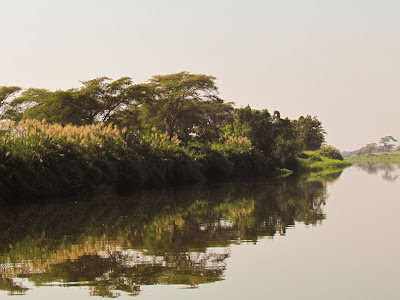
Below (top) is a photo from a river trip into the Zone Annex on the Lufira River. It shows some of the common Acacia thorn-trees right along the river; in this case the structure takes the appearance of a gallery forest.
See the Google Earth Image (above) which shows one of these savannas from the air
in the Kundelungu ANNEX with the "forest" in a CUT-OFF MEANDER scar along the Lufira River Note the muddy river meandering to the right vs the "dry" meander scars farther to the left. Much of the surrounding landscape is either wetlands (the greener areas) or grassland savanna on higher better drained ground.
Above is a view of a typical fixed wetland--in the lower left foreground--with aquatic grasses/shrubs, in the Kundelungu ANNEX with the "forest" in a CUT-OFF MEANDER scar along the Lufira River Note the muddy river meandering to the right vs the "dry" meander scars farther to the left. Much of the surrounding landscape is either wetlands (the greener areas) or grassland savanna on higher better drained ground.
e.g. bulrushes near Kiubo Falls as viewed from the Lufira Bridge. There is a dense gallery
forest to the top right and an Acacia Savanna Woodland toward the top left.
b) Transitional Tree/Bush Savanna of the Mid-Plateau and Valleys:
This savanna formation has more scattered trees and may in fact simply be a judgement call in terms of % tree-covered (?) and probably reflect long term fallow from swidden agriculture. The
FAO / LCCS (Land Cover Classification used by the Tervuren may--TREE SAVANNA or BUSH SAVANNA may in fact be the right classification. Again, it depends on what threshhold measure was chosen for the classification. But without seeing the original data and imagery it is difficult to evaluate which class best fits a particular area. As mentioned earlier a good measure for separating forest from savanna types is the
PERCENT TREE COVER:
>60% = wooded or tree savanna
25-60% = Bush/Shrub Savanna
<25% = Grass Savanna
A "bush/tree" savanna near Lukafu which is actually a FALLOW AREA.
Note the re-sprouting shrubs/bushes after the fire used to prepare for planting
A small grass/bush savanna surrounded by Dry Forest--an area which has been
put in agriculture and of course burned. This may be the classic "transitional" savanna
that several different systems use as classification. Note the DRY FOREST on the hillside.
A Bush/Shrub Savanna near Katwe Station in Kundelungu
A tree-savanna and shrub savanna adjacent to each other near Lusinga Station in Upemba
c) DAMBO SAVANNAS (see also Aquatic Biotopes HERE)
Classifying them is somewhat of a conundrum--they could be classed as a savanna or as a special AQUATIC Biotope. As mentioned previously, DAMBOS are one the most unique habitats to be found in either park. They are often associated with small marshes, ponds, and patch forests. In essence, they are small seasonally-flooded savannas found in very small low-lying, poorly-drained depressions on the High Katanga Plateau (see more photos below in the previous post). In these minute depressions or on very flat surface areas, excessive water accumulates in the rainy season, and, because of underlying clay or laterite layers that impedes good soil drainage, the soil is often waterlogged. Yet during the rather intense and longer dry season, the soil dries up thus making it hard for shallow-rooted shrubs or bushes to grow.
But along the edges where there is a little more topography i.e. high spots, deep-rooting trees may survive and particularly farther down slope where the water in groundwater may seep out as springs allowing patch forests and riparian woodlands to form. In sum, many of the variations in plant types (woody vs herbaceous plants) and even insects (presence of specific types of termite mounds or ant hills) can help explain landscape ecology along with, of course, the impact of fire, and animal predation and grazing effects. Here are a few pictures again:
d) The Rocky (copper-cobalt rich) Steppe Savanna
This unique landscape is associated with rock outcrops in the region that are rich in copper and cobalt ores. It contrasts from the predominant Open Miombo Forest by the presence of certain species that do well on the ore-rich soils, e.g. Haumaniastrum robertii, Monadenium cupricola, and Faroa malaissei. These soils may also favor growth of unique small mushroom-like termite mounds (see previous discussion under DAMBOS regards "termite mound savanna".
Note the GALLERY FOREST in the distance.
The rocky outcrops are clearer after fire has gone through.
Some small "mushroom-like" termite mounds and
re-sprouting shrubs after fire.
e) Steppe Savanna--short and tall grass types
As mentioned earlier, of particular interest on the HIGH PLATEAU OF KUNDERLUNGU are patches of sandy sediments/soils redeposited by wind and water from an earlier geological phase known as the Plio-Pleistocene or the so-called Kalahari Desert Sands. Depending on location, i.e. drainage and soil depth, these soils can provide a favorable habitat for specific kinds of grasslands--some short grasses (usually bunch grasses)--therefore the name "Steppe" Savannas. while others favor taller grasses (see photos below) from what is called LA GRANDE SAVANNE on the Kundelungu High Plateau. as well as the savannas around Lusinga Station in Upemba. The latter is where one finds the remaining ZEBRA in DRC.
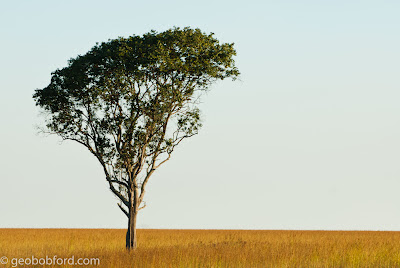
Grassland Savanna with a lone tree near Lusinga Station in Upemba National Park
Some of what is estimated to be only 29 Zebra left in the entire DRC
Tall Grass Savanna in Kudelungu with wildflowers in foreground
(along a track) and a PATCH FOREST in the distance.
NEXT: SUMMARY > Consulting in Kundelungu and Upemba Parks Katanga/DRC
Robert (GeoBob) Ford,
Rockville, Utah August 22, 2012


Hello Bob,
ReplyDeleteYour photography is quite beautiful. I'm really enjoying seeing your photos of DRC's town life in Lubumbashi and the beauty of the parklands and savanna's nearby. From other pix my husband had taken around Lubumbashi, I had thought there were few trees and grass, that it was most dry high desert country. I'm getting a different perspective through your camera lens.
Cindy
Thanks Cindy! The view of the region depends a lot on whether you see it in the dry or wet season. The change can be stunning. DRC (and specifically Katanga) has great beauty and a lot of issues to resolve--and it is such a rich country!
ReplyDelete